General News
1 March, 2020
Autumn to be warmer and dryer than normal
The BOM's latest tropical climate note suggests monsoon-break conditions are likely to return to northern Australia, with drier-than-average conditions forecast for FNQ in autumn
As summer officially came to an end last night, it looks like it was another scorcher for the record books.
Official numbers won't be processed for a few days, but it will surprise few that according to the Bureau of Meteorology, it is looking like summer 2019/20 will be in the top three years of records for daytime temperatures.
Despite good rain for some areas in February, summer rainfall was below average for the country as a whole. Bureau climatologist Dr Andrew Watkins said summer was the tale of two halves and two main climate drivers.
"At the start of summer, we saw both a very strong positive Indian Ocean Dipole and a near-record negative Southern Annular Mode, and that resulted in both the warmest and driest December on record, with significant fire weather throughout many parts of the country," Dr Watkins said.
"In January we saw those two drivers return to neutral levels, plus a very late arrival of the northern monsoon which finally brought tropical moisture to the continent.
"As we often see once the monsoon arrives in the north, some of that tropical moisture was dragged south leading to some of the good recent rainfall over the country's east.
"The rainfall helped contain many of the long-lived bushfires in the east and helped ease drought conditions in some locations. But many inland regions experienced only patchy rainfall and we still need to see sustained rainfall to relieve drought in many areas.
"Although the extra moisture and cloud moderated temperatures compared to the record warm December, January and February will still rank among the ten warmest on record for the country as a whole."
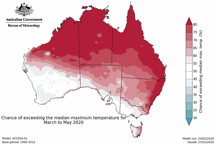
The outlook for autumn shows both daytime and overnight temperatures are likely to be above average for most of the country, but there is no clear temperature signal further south.
In terms of rainfall, Dr Watkins said many areas were showing no strong push towards wetter or drier than average conditions in the coming months. However, some parts of the tropical north may have a drier end to their wet season and parts of southern and south-eastern Australia are showing a slightly increased chance of above-average rainfall in the coming three months, particularly in March.
"The low likelihood of widespread above or below-average rainfall is largely due to our significant climate drivers – such as ENSO or the IOD - being neutral. We're not expecting these neutral patterns to change over the season."
"All international models analysed by the Bureau are currently showing our climate drivers in the Pacific or the Indian Ocean remaining neutral in the coming months. By winter, we will have an even clearer indication if this will change, and hence what the weather will look like for the rest of 2020."
Both days and nights were warmer than average across most of the country, and record warm for areas of northern Australia and southern Western Australia.
Summer was drier than average for Australia as a whole but particularly dry in western NSW, SW Queensland and the Top End. Conversely, conditions were wetter than average along coastal areas of NSW and large parts of inland WA.
QUEENSLAND - Autumn outlook:
Daytime and overnight time temperatures are likely to be above average for most areas.
In terms of rainfall, most areas are showing no strong push towards wetter or drier than average conditions, but parts of northern Queensland are likely to be drier than average over the autumn months.
The BOM's latest tropical climate note suggests monsoon-break conditions are likely to return to northern Australia, with drier-than-average conditions forecast for FNQ in autumn.