Advertisment
General News
22 February, 2020
Cyclone predicted for the Gulf
he Bureau of Meteorology (BOM) expected Queensland's first cyclone to form tomorrow in the Gulf of Carpentaria near the Northern Territory-Queensland border.
It looks as though the Tableland's and Far North Queensland are set for a wet couple of days, with the Bureau of Meteorology (BOM) expecting Queensland's first cyclone to form tomorrow in the Gulf of Carpentaria near the Northern Territory-Queensland border.
Heavy Rain is expected with the potential to cause flash flooding around the Gulf of Carpentaria over the coming days. Flood Watches are current for Gulf of Carpentaria catchments.
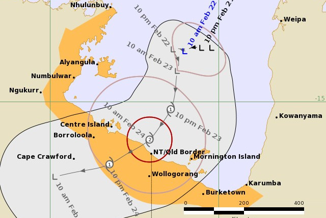
Watch Zone: Karumba (Qld) to Nhulunbuy (NT), including Mornington Island, Borroloola, Wollogorang, and Groote Eylandt, and nearby inland areas between Borroloola and Burketown. (issued by BOM at 11.16 am)
If the weather system does progress into a cyclone, it will be named Cyclone Esther. Localised flooding is expected to impact the north-west Gulf between the Queensland and NT border and Karumba.Conditions would likely ease Tuesday as the system was forecast to move west towards the central Northern Territory and away from Queensland.
To keep up to date with Queensland's weather warmings http://www.bom.gov.au/qld/warnings/
Advertisment