General News
28 February, 2021
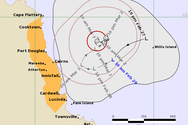
FNQ on Cyclone Watch
A tropical low may produce gales about exposed parts of the north tropical coast as it develops into a tropical cyclone, most likely on Tuesday.
A tropical low may produce gales about exposed parts of the north tropical coast as it develops into a tropical cyclone, most likely on Tuesday.
The warning zone is Cape Flattery to Lucinda, including Cairns, Port Douglas, and Innisfail.
Details of Tropical Low at 10:00 am AEST:
Intensity: tropical low, sustained winds near the centre of 45 kilometres per hour with wind gusts to 85 kilometres per hour.
Location: within 35 kilometres of 16.8 degrees South, 148.3 degrees East , 270 kilometres east of Cairns and 255 kilometres east northeast of Innisfail.
Movement: south at 11 kilometres per hour.
The tropical low is expected to remain slow-moving off the north tropical coast while continuing to develop. It is expected to reach tropical cyclone strength on Tuesday morning. Although a direct coastal impact is not expected, gales are possible about exposed coastal and island areas as the system reaches cyclone strength. Heavy rainfall is also likely.
In the longer term, the system is expected to take a southeasterly track late in the week while remaining off the coast.
Hazards:
GALES are not expected during the next 24 hours, however, GALES with gusts to 100km/h may develop about exposed coastal and island areas between Cape Flattery and Lucinda, including Cairns and Innisfail, on Tuesday morning depending on the movement and development of the system.
HEAVY RAINFALL may develop about coastal and island areas between Cape Flattery and Lucinda, including Cairns and Innisfail, over the next several days. A Flood Watch is current for the north tropical coast between Mission Beach and Rollingstone; refer to that product for more information.
ABNORMALLY HIGH TIDES are likely over the next several days. Large waves may produce flooding near the foreshore. People living in areas likely to be affected by this flooding should take measures to protect their property as much as possible and be prepared to help their neighbours.