General News
26 January, 2021
Tropical Cyclone Advice for Tuesday January 26.
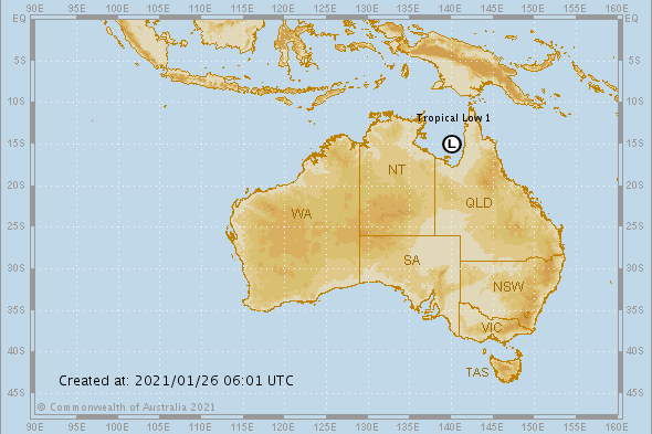
A Tropical Cyclone Watch has been declared between Aurukun and Karumba, including Mornington Island, for the developing tropical low in the Gulf of Carpentaria.
A Tropical Cyclone Watch has been declared between Aurukun and Karumba, including Mornington Island, for the developing tropical low in the Gulf of Carpentaria.
The tropical low is expected to move slowly towards the Qld coast and develop into a tropical cyclone on Wednesday night or Thursday.
The system should remain slow-moving in the southeastern region of the Gulf of Carpentaria for several days, beyond that there is a range of possible scenarios including crossing over the Cape York Peninsula or heading towards the Northern Territory.
Heavy rainfall is forecast about western parts of the Peninsula, with the potential for 100 to 200 millimetres per day for multiple days. Tides in the Gulf may exceed Highest Astronomical Tide (HAT) in the coming days due to increased monsoonal flow, particularly if the tropical low in the Gulf of Carpentaria develops.
A strong wind warning is current for Gulf waters today and tomorrow as the low develops. Isolated showers and the odd thunderstorm around coastal areas today (most likely in the morning) and adjacent inland areas (most likely in the afternoon) of the state. Isolated afternoon showers and thunderstorms about the far west of the state, mostly sunny elsewhere. Isolated shower and thunderstorm activity spreading east into the interior over coming days as a trough moves slightly east. Increasing chance of showers about coastal regions towards the end of the week as a southeast surge works its way up the coast, with tides increasing to near HAT about the southeast from Wednesday.
Monsoonal conditions persisting about the Peninsula over the coming days. Temperatures generally 1-3 degrees above average away from the coast today with low-intensity heatwave conditions forecast for central, southern, and western districts over the coming days.